Mapping Service

Multiplex Drone offers advanced Mapping Services using state-of-the-art drone technology to deliver highly accurate and detailed aerial data. Our DGCA-certified drones are equipped with the latest sensors and high-resolution cameras to provide comprehensive mapping solutions for a variety of sectors, including agriculture, commercial use, surveying, and mining.

Our drone mapping service is designed to help farmers, landowners, businesses, and surveyors obtain real-time, actionable data for effective decision-making. With the ability to capture both 2D and 3D maps, our drones provide unparalleled precision in mapping agricultural fields, construction sites, commercial properties, mining areas, and more. Whether you’re a farmer looking to improve crop yields or a business needing accurate topographical data, our service has you covered.
In agriculture, our drones provide insights into crop health, soil conditions, irrigation needs, and yield predictions. For commercial use, we offer accurate land surveys, boundary mapping, and detailed site planning. Our drones are also ideal for mining surveys, where they can create detailed maps of mining operations, identify material stockpiles, and monitor site conditions.
Our service reduces the time and cost associated with traditional surveying methods, while delivering high-quality, precise results. The data provided can be used for various applications, including precision agriculture, land development, site planning, environmental monitoring, and resource management.

Multiplex Drone’s Mapping Service delivers powerful insights through detailed and accurate aerial imagery. Our drones utilize high-resolution cameras and multispectral sensors to capture essential data for various industries. Whether it’s assessing crop health, creating detailed land surveys, or conducting mining site analysis, our service helps businesses and farmers make data-driven decisions.

For agriculture, our drones generate critical data that supports crop health monitoring, precision irrigation, soil mapping, and yield predictions. In commercial sectors, we provide 2D mapping for land development, construction site planning, and urban planning. For surveying purposes, our drones are ideal for topographical mapping, site analysis, and boundary demarcation, while in the mining industry, we offer comprehensive surveys of mining operations, material stockpiles, and terrain mapping.

Types of Mapping Applications

Agricultural Mapping

  • Crop health monitoring
  • Soil condition analysis
  • Irrigation management
  • Yield predictions
  • Precision farming for large-scale farms

2D Mapping for Commercial Use

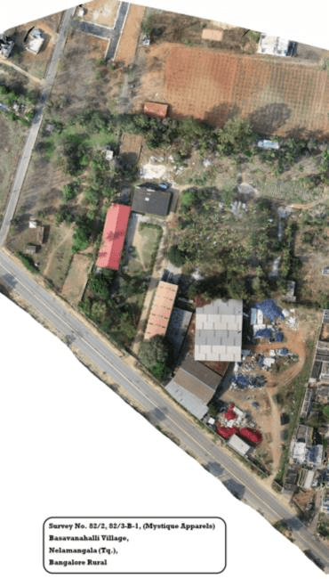
  • Land survey and boundary mapping
  • Construction site planning and management
  • Urban planning and zoning
  • Infrastructure assessment
  • Property and real estate surveys

Survey Mapping

  • Topographical mapping
  • Land-use analysis
  • Site boundary demarcation
  • Environmental assessments
  • Elevation and contour mapping

Mining Survey Mapping

  • Detailed mine site analysis
  • Material stockpile measurement
  • Terrain and topography mapping
  • Safety and compliance monitoring
  • Volume estimation for mined materials

Key benefits include

  • Precision Agriculture – Monitor crop health, identify nutrient deficiencies, and manage irrigation effectively.

  • Commercial Mapping – Site development, boundary mapping, land-use analysis, and detailed survey reports for commercial projects.

  • Mining Surveys – Detailed topographical maps, stockpile measurement, site conditions analysis, and environmental monitoring.

Our drones save time, reduce costs, and deliver accurate 2D and 3D maps that are essential for various sectors. With over 100,000 acres mapped and successful mapping of mining and commercial projects, we have proven expertise in delivering reliable, actionable data.

Contact Us

Have any questions or need assistance? Reach out to us today!

    * – fields are required


    * – fields are required


    Scroll Down